The highest peaks of the Cantabrian Mountains lie in this stretch of land where the legendary history of Asturias began.
Various folds and ice ages have given shape to an intricate landscape and the influence of ice and water on the limestone has formed a grandiose karst mountain range. The three main massifs of this natural wonder are bordered by deep valleys and gorges created by erosion caused by glacial tongues and the power of the rivers, which even today shape the limestone rock to their liking. The rivers Dobra, tributary of the Sella, and Deva flank the mountains to the west and east, while the Cares and its tributary Duje divide the national park into its three massifs.
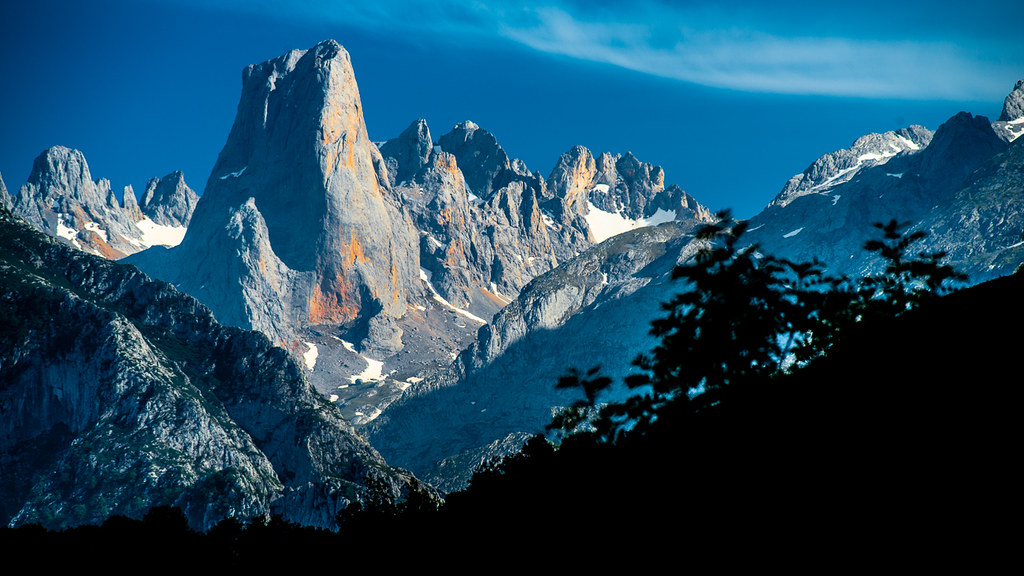
In the Massif Central, the highest peaks of the Cantabrian Mountains are in the rugged „Los Urrieles“, where the majestic symbol of the Picos de Europa rises: the immense beauty of Naranjo de Bulnes or Picu Urriellu. Its 2,519 metres of intricate orography have not prevented human settlement, famously the village of Bulnes. Until 2001, this village was only accessible by a narrow and steep mountain path. Since then, access has become easier thanks to the rack railway that crosses the mountains from the village of Poncebos.
To the east of the Urrieles is the eastern massif, „Macizo de Andara“, the smallest massif with a gentler profile, whose highest peak is the „Morra de Lechugales“ at 2,400 metres. The westernmost of the three massifs are the „Picos del Cornión“ near Covadonga, a place of pilgrimage visited by thousands of pilgrims every year. The mountain lakes of Enol and Ercina reflect the proud mountains where the legendary history of Asturias began.
In the cave of Covadonga itself, under the image of the Virgin, the omnipresent traces of karstic phenomena in the Picos can be observed in the photogenic example of the karstic source of the River Orandi. The central and western massifs are separated from south to north by the Cares River, whose crystal-clear waters have cut deep into the rocks. Among the stately peaks of the Western Massif, „Peña Santa de Castilla“ stands out at 2,596 metres high. On the way there, the viewpoint „Mirador de Ordiales“ is located above a landslide of almost 1,000 m depth, which drops down to the valley and amazes every visitor.
Translated with www.DeepL.com/Translator (free version)
Die höchsten Gipfel des Kantabrischen Gebirges liegen in diesem Landstrich, in dem die legendäre Geschichte Asturiens ihren Anfang nahm.
Verschiedene Faltungen und Eiszeiten haben einer verschlungenen Landschaft Form gegeben und der Einfluss von Eis und Wasser auf das Kalkgestein hat ein grandioses Karstgebirge gebildet. Die drei Hauptmassive dieses Naturwunders werden begrenzt durch tiefe Täler und Schluchten, die durch die von Gletscherzungen verursachte Erosion und die Kraft der Flüsse entstanden sind, die auch heute noch das Kalkgestein nach ihrem Belieben gestalten. Die Flüsse Dobra, Nebenfluss des Sella, und Deva flankieren das Gebirge im Westen und Osten, während der Cares und sein Nebenfluss Duje den Nationalpark in seine drei Massive teilen.
Im Zentralmassiv befinden sich die höchsten Gipfel des Kantabrischen Gebirges in den schroffen „Los Urrieles“, wo sich das majestätische Symbol der Picos de Europa erhebt: die gewaltige Schönheit des Naranjo de Bulnes bzw. Picu Urriellu. Seine 2.519 Meter komplizierter Orografie haben die menschliche Ansiedelung nicht verhindert, berühmt ist das Dorf Bulnes. Bis zum Jahr 2001 war dieses Dorf nur über einen schmalen und steilen Gebirgspfad erreichbar. Seither hat sich der Zugang dank der Zahnradbahn, die das Gebirge ab dem Dorf Poncebos durchquert, vereinfacht.
Östlich der Urrieles liegt das Ostmassiv, „Macizo de Andara“, das kleinste Massiv mit sanfterem Profil, dessen höchste Bergkuppe die „Morra de Lechugales“ mit 2.400 m Höhe ist. Das westlichste der drei Massive bilden die „Picos del Cornión“ in der Nähe von Covadonga, einem Wallfahrtsort, der jährlich von tausenden von Pilgern besucht wird. In den Gebirgsseen Enol und Ercina spiegeln sich die stolzen Berge wider, in denen die legendäre Geschichte Asturiens ihren Anfang nahm.
In der Grotte von Covadonga selbst, unter dem Bildnis der Jungfrau, sind die allgegenwärtigen Spuren karstischer Phänomene in den Picos am fotogenen Beispiel der Karstquelle des Flusses Orandi zu beobachten. Das Zentral- und das Westmassiv werden von Süd nach Nord durch den Fluss Cares getrennt, dessen kristallklares Wasser sich tief in die Felsen geschnitten hat. Unter den stattlichen Gipfeln des Westmassivs ist „Peña Santa de Castilla“ mit 2.596 Höhe hervorzuheben. Auf dem Weg dorthin liegt der Aussichtspunkt „Mirador de Ordiales“ über einem Bergrutsch von fast 1.000 m Tiefe, der bis ins Tal hinab fällt und jeden Besucher in Staunen versetzt.